


- 3D/2N
- Uttarkashi
- 3D/2N
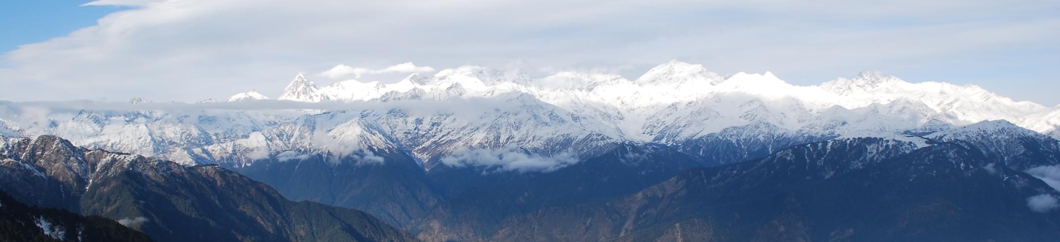
Beauty Of Himalayan Treks, A large part of Uttaranchal is situated below the range of Himalayas in the northern part of India with dense forests, rivers, peaks, mountains that enhances its beauty. Uttaranchal is a major tourist attraction. It is a perfect place to discover the nature at its best and explore it too.
When one walks through the un-explored settings and observes the nature around, its the part of Uttarakhand left behind. Seku village (5500 ft / 1700 mts), 2 hrs walk from Kuflon, an alternate trek route to Dodital, is one of the very few villages in the region to have been unscathed by the regular visits from the outsiders. Mainly an agro-dependent economy, it has started moving towards greener pastures. The settings of the village offer a mix of the past and the encroaching modern influence.
A village named Kuflon, is a well known eco-Friendly nature camp that is about 12 kms from Uttarkashi. It is located about 2 kms from a place called Sangamchatti at an altitude of 5000 ft. Its the part of Uttarakhand. Kuflon must be explored by outdoor activities of camping, bird watching, trout angling that gives a unique experience of thrill and adventure. The narrow stream called Assi Ganga flows through the hills that abounds in Brown trout and is favourable for the adventurous sports for tourists visiting Kuflon. The best season to visit this place is from September till July ending. This is the time for nature sports and time to enjoy incomparable hospitability from the villagers.

- 7D/6N
- 7D/6N
Tons Valley, located west of Garwal Himalaya, is a thick forest of pine and deodar mixture. The valley remains a tourist center.Ruinsara Lake engulfed by several glittering peaks is actually serene haven.The area being a section of great Govind Sanctuary, this place is filled with Indians diverse wildlife and it stays the heart of nature and bird watchers.Villages made of unique wooden carvings along the highway perplex watchers. Ruinsara Lake lies within the popular Swargrohini ranges and this place is nearly married by Hindu Mythology. The famous route carries historic weight as it remains part of Mahabharata Legendary epic.
Talk of heroes like Pandavas, who roamed in this region when they were serving 14 exile years. The Swargrohini trekking is the joyous, easiest and popular in the entire Garhwal Himalayas. Several alternatives exists whether to proceed directly to Himachal Pradesh or change direction to valleys like Garhwal. While trekking along Tons valley you will probably notice high mounts and thick forests surrounding this wonderful area.There are many such beautiful places in Uttaranchal. Binsar, Dodital etc. are some of them.

- 6D/5N
- Uttarkashi
- 6D/5N
About the Gomukh Tapovan Trek:
Within the 6 days of this Gangotri Gomukh Tapovan trek, one can marvel at the beauty of the Gomukh glacier, which forms one of the main sources of water for river Ganges. Along with your way to the peak, you can also visit several other attractions as well. This includes some of the popular and stunning pilgrimage sites in the area. The caves and huts housing ascetics at Tapovan are also quite inspiring. You will start the trek after reaching Rishikesh.
Uttarkashi to Gangotri will let you watch many holy rivers and landscapes which are the prominent attractions coming along with you. This trek will let you observe the magnificent beauty of Bhojwassa after you cover the well-laid paths leading to the region. The steep climbs leading to the high altitude meadows are conquered by many people before and you are also invited to catch the glimpses of the major towers in the Himalayan Ranges spreading across the region very closely by staying at the velvet type grasslands.
Witnessing the beauty of the stunning views of the Bhagirathi group of peaks, you will continue trekking to Gomukh and then towards Tapovan. Get a chance to witness the flora and fauna of the region as you keep continuing your trek on the seventh and eighth day. Conclude the trip after six days with precious memories created at the stunning locations.
About the Gomukh Tapovan:
Gomukh Tapovan Trek is considered as one of the most exciting and thrilling treks. Resembling the mouth of a cow, the Gomukh Glacier is one of the main water sources of the holy Ganges. Around the glacier, one can also view the peaks of Gangotri Group - Shivling, Thalay Sagar, Meru, and Bhagirathi III. In addition to its mesmerising beauty and appeal, it is also an important pilgrimage site for the Hindus and a dip in its water is considered as a sacred ritual.
On the other hand, Tapovan is located at the foothills of the Shivling Peak and is considered as a challenging route for the trekkers. Reaching a height of around 14,640ft, it is often thronged by the sadhus. This thrilling Gomukh Tapovan Trek takes you through some of the untouched places of the region. Marvel at the sight of the amazing beauty of the region as you keep continuing your trek. The sight of the Bhagirathi sisters glistening in the moonlight from Bhojbasa will make you stare at it for long.
The trekking trail typically has steady inclines and level walks. Trek for another 20-30 minutes and you will see another stream gushing below a makeshift bridge. You get clear perspectives of the Bhagirathi crests from Chirbasa. Additionally unmistakable out there is the mouth of the glacier. Your trek to Gomukh Tapovan will be one of the most memorable treks for you.
Gomukh Tapovan Trek Highlights:
- Enjoy camping at a high summit and the clear night sky under the billions of stars. Also, enjoy a small bonfire with your friends.
- Get a chance to witness the rare flora and fauna of this region as you continue your trek.
- Catch the glimpses of magnificent Bhagirathi peaks from Chirbasa. Also visible in the distance is the mouth of the Gaumukh glacier.
- During your trek you will also trek through Chota Jhandidar and Bada Jhandidar.
- The snow-capped mountain and the distant valleys will definitely make you wish to come back here once again.
- Trek to Bhojwassa which is studded with trees and is mostly barren and often compared to the Arctic Tundra region.
- Also, get a chance to visit Kriti and Meru glacier during your trek.
Quick Facts About Gomukh Tapovan:
Temperature: Day: 12°C to 17°C and Night: 2°C to 7°C. Can drop to -2°C to -3°C at Tapovan
Maximum Altitude: 14200 ft
Gomukh Tapovan Trek Difficulty Level: Moderate-Difficult
Railway Station: Dehradun Railway Station
ATM: Uttarkashi has the last ATM point before your trek begins.

- 16D/15N
- Uttarkashi
- 16D/15N
Auden’s Col is one of the high altitude mountain passes set at an altitude of 5490 meters. This Col is a depression in the ridge that lies between Gangotri and Jogin massifs in the Garhwal Himalayas. The Auden’S Col Trek connects the valleys of Bhilangana and Rudragaira and is one of the toughest non-technical treks in the country. It is characterized by precarious ridges, dangerous moraines, numerous crevasses, a long strenuous trail and boulder sections.
Auden Col Trek hosts a shrine and is filled with sites for Hindu pilgrimage. When trekking you get to witness the majestic views of the Kedar Dome, Bhagirathi, Jogin, and Rudragaira peaks. This trail that passes through numerous hamlets, gushing streams, thick alpine jungles, and meadows sprinkled with a variety of blooms, will leave you stunned.
About Auden’S Col Trek:
Set at an altitude of 5,490 m, the Auden's Col is one of the high altitude mountain passes in the Garhwal Himalayas that connects the Rudragaira valley and Bhilangana valley. Forming a bridge between the north-west ridge of Gangotri-III and Jogin-I, it reaches an altitude of 5,390 m.
The Auden’S Col Trek is also one of the toughest treks in the Garhwal Himalayan region and hence it has been the least explored one by regular trekkers; a dream for all the ardent trekkers. It will take you through some of the dangerous moraines, narrow cliffs and stony, snaky and twitchy paves.
Auden's Col Trek is filled with Hindu pilgrimage sites and hosts a shrine and views that your eyes can fathom. The trail passes through the thick alpine forests, meadows dotted with varied species of flowers, gushing streams, and cuts through numerous villages. Even being a strenuous trail, the journey is treated with the majestic view of the hulking high peaks like the Rudragaira, Jogin, Bhagirathi and Kedar Dome. Not just a trek, but it is an expedition that would rejuvenate and inspire you!

- 13D/12N
- Uttarkashi
- 13D/12N
About the Panpatia Glacier Trek:
Surrounded by legends and fables the Panpatia Glacier trek that takes you through Panpatia Col route requires endurance and willpower to get through harsh yet beautiful nature. Located between the holy shrines of Badrinath and Kedarnath, the region is rich with wondrous stories of ‘sadhus’ and sages who have lived here.
The journey kicks off from the holy Badrinath Shrine; a place where Shiva and Parvati are believed to have lived. Stay in charming campsites in alcoves, along lakesides and over flatlands on the way and enjoy walking through a trail that is well planned and fun at the same time. Marvel the magnificent peaks of Chaukhamba and Nanda Devi to finally come to a landscape that is as white as snow can be! Wherever your eyes go you can see the vast snow fields that have inspired many holy journeys!
About the Panpatia Glacier:
Panpatia glacier reigns at a stunning altitude of 17,257 ft., and bridges two of India’s most revered pilgrimage sites, Kedarnath and Badrinath. Shrouded in haloes of myth and legends, the Panpatia Glacier trek shows you how beautiful as well as lethal nature can be. It takes you through a diverse terrain including high altitude passes, moraines, terrifying cliffs, and roaring streams. This trek borders on a Himalayan expedition granted the semi-technical mountaineering techniques that are required. The most alluring lore that veiled the trek was that in ancient times, priests and sages could cover the trek from Badrinath to Kedarnath in just a day!
One of the most challenging treks in Uttarakhand, the Panpatia Glacier trek puts your stamina and determination to test. The trail of the Panpatia Glacier trek originates from Badrinath, landing eventually at Nilkanth Khal. It harbours some of the most scenic campsites and meadows perched along the serene banks of glacial lakes. It unfolds a carpet of vibrant floral species that captivate the senses. The view opens to mighty Himalayan behemoths like Nilkantha, Chaukhamba, Nanda Devi, Kunaling, and Balakun.
Catch breathtaking glimpses of the snout of the actual glacier and Panpatia plateau. This trek is enjoyed best during the summer and autumn months.
Though the trail is rugged in some sections and laden with loose stones, crevasses and icefalls, no other trek holds a candle to the beauty and the panoramic views of its Himalayan neighbours. Also, walking on an actual glacier is petrifying, no doubt, but is also ten times more exhilarating! Lose yourself amidst myth, lores, and a devastatingly beautiful Himalayan heaven as your eyes feast on the magnetic snowy views, and your soul sways in the alluring wilderness
Quick Facts about Panpatia Glacier Trek:
Region:- Garhwal, Uttarakhand
Duration of the Panpatia Glacier Trek: 13D (including a contingency day) /12N
Activities: Trekking, Climbing, Camping
Highest Altitude: 5260 Mt.
Temperature Range: 10 to12 Degrees (night), 24 to 25 degrees (daytime)
Best Time:- April to June & September to October
Panpatia Glacier Trek Difficulty Level: Moderate To Challenging.